A Trip to the Grand Canyon National Park.......by Dr Rachhpal Sahota
United States, May 30, 2021: Last week, I crossed off one item from my to-do wish list; I finally made the wonderful trip to the Grand Canyon with my friends and family. When, years ago, I first heard of the Grand Canyon, I didn’t know what a ‘canyon’ was. The dictionary defined it as a ‘deep, narrow valley with steep sides, invoking in my mind images of the valleys I had seen in the Himalayas—elongated depressions between hills with a river flowing through it—to which one could descend with relative ease from numerous points.
But later, a friend corrected my imagination—a canyon is more like a long, narrow, steep ditch cut in the rock by a river. Since it is a cut rock, descending into a canyon is not nearly as friendly as climbing down a dirt mountain.
The Grand Canyon is a steep-sided canyon carved by the millions of years of hard work of the Colorado River. With a river length of 277 miles, the Grand Canyon is considered to start at Lees Ferry, where one can reach the river by driving to it and end at Grand Wash Cliffs, where the Colorado River enters Lake Mead. It is up to 18 miles wide and more than a mile deep. However, for tourism purposes, a much smaller area of the Canyon, known as its corridor region, where one can walk down to the Colorado river using established trails, is the key.
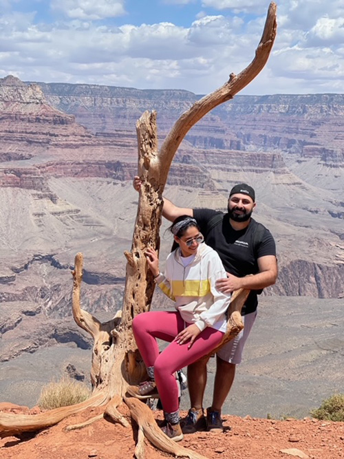
Our group consisted of eighteen people, nine in their sixties and nine young adults between 25 and 34. The trip was a resurrection of our old days when we used to go camping together—the now young adults of the group were children then. Ruby, our group leader, had reserved six RVs for us at the Canyon Gateway RV Park, Williams, AZ, an attractive lodging choice. All six RVs were together, making it easy for us to get around a fireplace in the evenings.
First Day -the Plane Ride: The youngsters, Hermondeep, Amneet, Jay, Lisa, Jyoti, Bikram, Herman, Jasline, and Arsh, met online to put together a four-day plan for the group. Eight of the group arrived in Williams on the evening of Friday, May 5. and the others on Saturday. The first activity for those coming on Friday was the plane ride over the Canyon. We drove to the Grand Canyon Airlines early in the morning. Grand Canyon Airlines is the longest-running air tour service in the world. It started its service in 1927 and has completed over 90 years of entertaining Grand Canyon visitors. Their airplane fleet includes the 19-passenger Vistaliners and the 9-passenger Cessnas. Captain Jack was waiting for us with a Cessna, big enough for our group of seven.
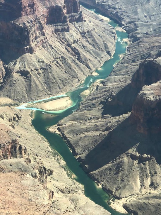
The flight was about 45 minutes long. None of us had much knowledge of the Grand Canyon, and this as our first activity turned out to be a good decision; it gave us an overview of the Canyon. Before flying over the Canyon Rim, you notice hundreds and hundreds of acres of yellow pine lining the Canyon. With a scanty average rainfall of 13 inches a year, one marvels at the workings of nature—how do these pinecones take root in that arid land to create such a dense jungle.
The views from the plane were breathtaking. The vastness of the Grand Canyon overwhelms you; everything seems to be outside of this world, from the lush green pine-lining to the rugged wilderness of the Grand Canyon. You witness canyons within the Canyon and watch with awe the rock walls, the gorges, the steep cliffs, the sinking slopes, and shades and shades of the rusty, red, black, pink, and brown rock with towers of rock formation sticking up. At the bottom flows, like a snake, the Colorado River. The confluence where the turquoise-colored water of the Little Colorado River merges with the blue-green Colorado River is an exquisite spectacle.
Trekking down the Canyon:
A brief history: Before I describe our experience, a brief history of trekking down the Canyon will be helpful. Though there are signs of native Indians having lived in the caves along the Grand Canyon, not much is on record on the Canyon traffic; it was almost impossible to descend those steep rock cliffs for humans. The Havasupai Indians used a route to access what is now known as Indian Garden, halfway down the Canyon 3000 feet below the surface. The course attracted Ralph Camaron, a future US senator’s attention in 1887, who believed copper and gold were near Indian gardens. He developed that route further for commercial purposes, and it came to be known as the Bright Angel Trail.
Over the next few decades, an unimaginable amount of hard work went into developing what we now know as the Grand Canyon trail system. Rocks had to be blasted using dynamites, and it took many lives. Two devastating floods ruined the trails resulting in significant reworks. The current Grand Canyon trail system includes two trails—the Bright Angel Trail and the South Kaibab Trail descending from the South Rim, and two trails—the North Bright Angel Trail and the North Kaibab Trail descending from the North Rim. The Bright Angel trails from the two sides meet via the Silver bridge over the Colorado River, and the two Kabab trails meet one another over the Black Bridge. A two-mile sandy track on the south side of the Colorado River, called the River Trail, connects Bright Angel Trail with the Kaibab Trail. This entire area is called the corridor area of the Grand Canyon, and the trails are referred to as the corridor trails. The Phantom Ranch, a beautiful lodge, an oasis at the bottom of the Grand Canyon, is built on the north side of the Black bridge, and it can only be reached on foot, by mule, or by rafting the Colorado River. There’s over a fifteen months’ wait if you wish to stay at the lodge, though its canteen offers excellent to-go food, even if you don’t have a reservation.
The exciting history of the Colorado River crossings and the two bridges is for another time. Suffice it is to say that the South Rim does not have any water source of its own – all water is pumped up from the spring near the North Rim. The water pipe across the Colorado River is suspended beneath the Silver bridge.
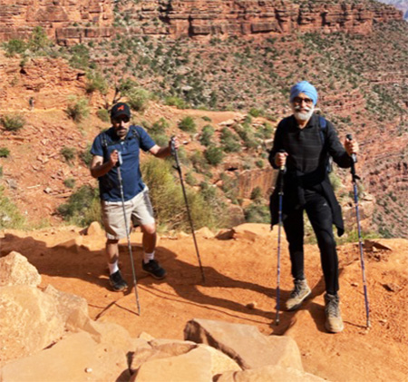
The first day of hiking: As a trial run for the upcoming long hiking the following day, we decided, after the plane ride, to go a couple of miles down the Kaibab trail. We had proper hiking gears—the hiking poles and the lightweight, two-litter water backpacks.
Although I consider myself to be pretty fit, I had never seriously hiked in my life. I thought going a couple of miles down the Canyon and back up should be a breeze. We strolled down to Cedar Ridge comfortably, chatting and taking pictures, leisurely taking two hours to reach there.
The bathrooms there were closed that day for maintenance, and by the way, there’s no water station there. I don’t believe there’s any water station along the Kaibab trail. Climbing back up was tough, but it didn’t feel too bad until we reached up, and I tried to talk. Physically I was feeling fine, but my voice would just not come out. “It looks like you have hiked twenty miles,” Raj said when I tried to talk to him.
In the evening, I had severe nosebleeds. I realized the reason – even though I had a two-liter water pack on my back, I did not drink a sip during the hike because I did not feel thirsty. Raj, a doctor by profession, scolded me for not keeping myself hydrated. We closed our day by the fire, and I drank at least two liters of water to get myself hydrated and ready for the big hike the next day.
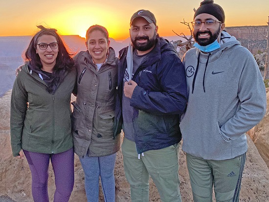
Watching the Sunrise at Mather Point: The Sunrise at Mather Point on the Rim Trail is an experience. And yes, I forgot to mention this twelve-mile paved trail around the South Rim, on top of the Grand Canyon. The following morning, we had to start our long hike at 7 AM, and around 11 PM the night before, we started debating about going to the Mather Point.
The Sunrise was at 5:28 AM, and the Mather point was more than an hour’s drive from the campground. Going for the Sunrise meant waking up before 4 AM; more than half of the group decided against it. I reluctantly joined the brave souls who did not want to miss the experience.
We had a late start in the morning and were unsure if we would even make it on time. There was hardly anyone on the road that early, and (shh…) we broke a few speeding rules but made it in the nick of time. Hundreds of others were waiting for the sun to show its face, and when it did, it was pleasant, and I was glad I had braved the morning.
The Long Hike: By now, we were all hungry and went to the Grand Canyon Village to grab a quick breakfast. We had decided the previous night to not wait for each other to start the hike, and the group got divided into four subgroups. Our goal was to go down the Bright Angel Trail to Indian Garden and back, making a total of 10 miles hike. It was an elevation change of 3,030 feet. Going down to the Colorado River would have doubled our distance and added almost 2,000 feet to the elevation change. There is a warning by the Grand Canyon authority to not make the trip to the river and back in one day.
Mind it, that notice is for us mortals; there is no shortage of people who can trek all the way from the North Rim to the South Rim (it is easier to go from North Rim to South as North rim is 1,100 feet higher – so you trek down more than you trek up) a distance of about 23 miles. And some people can hike from Rim to Rim to Rim (R2R2R), crossing the Canyon twice, covering 45 miles in one go. And hold on to your seat—on May 12, 2021, the day we returned from our trip, Austin Mallory Brook, a 37-year-old woman, set an R2R2R2R2R—that is crossing the Grand Canyon four times, covering a total distance of 90 miles in less than 25 and a half hours, breaking the previous such record by more than three hours.
But let’s get back to our hike. As expected, going down was easy.
As before, we took our time posing for pictures, and it took us about four hours to reach the Indian garden. The trail was generally rough, with smooth, gently slanting sections, interspersing the tougher on the knees, tall steps. There were numerous switchbacks along the way, with large boulders put at the bends to prevent people from running over the cliffs. To nail these rocks to the ground, workers had to be suspended in the air, sometimes more than 100 feet.
We passed by a supply mule train, with more than a dozen mules walking in line, tied to each other with ropes. Only three of the mules had riders to guide them. Signs were posted to respect mules and follow instructions given by the mule guides.
As a rule of thumb, to let mules pass, stand on the side of the hill, not the cliff. A mule is a sure-footed animal, but making a survival choice, it will choose itself over the bystander—leave enough room between the mule and yourself so as not to be crushed or bumped by the protruding load it carries.
If everyone follows instructions, there is not much of a chance for an accident. Still, every year dozens die on these trails. Though it is a small fraction of the six million or so people visiting the Grand Canyon every year, no one deserves to win that lottery. Falls, heat strokes, and dehydration are the usual causes of these deaths. Every year, three to four deaths are attributed to falls, usually from posing for pictures or taking pictures too close to the cliffs. Some rocks on the edges seem solid from the top, but years and years of erosion have left them paper-thin. No amount of being able to balance yourself will save you, if you step on such a rock. A few young men fell to their death, were skipping from rock to rock on the edge; a four-year fell to his death because he likely evaded his guardians attention. To protect yourself from dehydration and heat-related deaths, it is recommended you carry enough water with you and do not hike during the middle of the day, especially on hot summer days. Getting injured on the trail can be a costly business. During our descent, a woman sprained her ankle and had to be taken out by a helicopter. Although hanging from a helicopter on a sixty-meter rope can be an exciting ride, it can run into tens of thousands of dollars.
We had sandwiches and protein bars with us, which we enjoyed at the Indian Garden. There was plenty of shade, lovely benches, restrooms, and water taps. We rested for half an hour, replenished ourselves, and started on the return journey.
We were glad we had hiking poles. We met a young lady without them, and she was struggling to get up, trying to walk on her fours. Parminder, one of our team members, took pity and loaned the woman one of her two poles, asking her not to worry about returning it. The hiking pole infused a new life into the young lady.
She climbed ahead of Parminder and was waiting at the top to return the stick. The last mile of the hike was super challenging for all of us, including the young adults. I remembered an arch in the hill, right after we had embarked on our trail in the morning; we had posed for pictures there. The sign ‘Bright Angel Trail->’ comes after that arch. On our way back, I was ecstatic to reach that marker—’I made it,’ I thought. However, the couple hundred yards upward of that arch, I had forgotten about, felt like a mile. I’m delighted though, to report that the few liters of water I consumed during the hike paid its dividends in total—I did not lose my voice and made it back without much physical anguish.
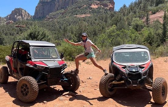
Day in Sedona: The town of Sedona is located at a little over an hour’s drive from Williams. It sits amidst the beautiful red rock and is known for its beauty and serene settings. The town is famous for its near 100 art galleries. However, it also offers excellent outdoor adventures like mountain biking, hiking, and off road excitement. The youngsters had planned ATV rides in Sedona.
Hitherto, I had never paid much attention to these vehicles. In my mind, teenagers who were not yet of age to get a driving license drove these ‘slow-moving carts’ to satisfy their driving fancy. Boy, was I wrong, or was I wrong? I learned why these are called All Terrain Vehicles. To begin with, some of these can run at over sixty miles an hour, and those rugged rocky terrains were not any hindrance for them. With young blood behind those steering wheels, I had to hold on to my dear life—my adrenalin levels went through my head.
A Dip at the Grasshopper Point: Sedona also offers a few sweet swimming holes. A few young people decided to go down to the Grasshopper Point, one of these beautiful swimming places, and later teased us with videos showing them jumping into the water from a cliff.
The last day: Most of the group that came on Saturday had already left, and it was the plane ride day for the rest of the group. Manjeet, my wife, and I had already taken the ride, and we decided to walk the paved Rim Trail instead. We had walked about eight miles when we got the call; they were done with their rides. We met for dinner at the Grand Canyon Brewing and Distillery in Williams, AZ, to conclude our trip.
-

-
Dr Rachhpal Sahota, Scientist , USA
rachhpalsahota@hotmail.com
Disclaimer : The opinions expressed within this article are the personal opinions of the writer/author. The facts and opinions appearing in the article do not reflect the views of Babushahi.com or Tirchhi Nazar Media. Babushahi.com or Tirchhi Nazar Media does not assume any responsibility or liability for the same.